


Ilet des Orangers - Riviere des Galets

lgmalherbe
User
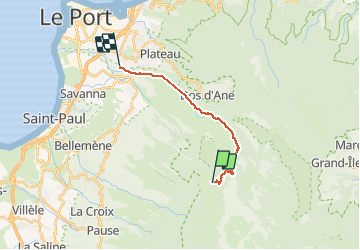

Length
18.9 km

Max alt
1059 m

Uphill gradient
420 m
Km-Effort
28 km

Min alt
107 m

Downhill gradient
1363 m
Boucle
No
Creation date :
2019-08-18 04:15:17.584
Updated on :
2019-08-18 08:42:57.95
4h26
Difficulty : Easy

FREE GPS app for hiking
 SityTrail
IGN / Geographical institutes
SityTrail Plus
The world is yours!
About
Trail Walking of 18.9 km to be discovered at Réunion, Unknown, La Possession. This trail is proposed by lgmalherbe.
Photos


Positioning
Country:
France
Region :
Réunion
Department/Province :
Unknown
Municipality :
La Possession
Location:
Unknown
Start:(Dec)
Start:(UTM)
332316 ; 7672341 (40K) S.
Comments